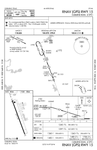
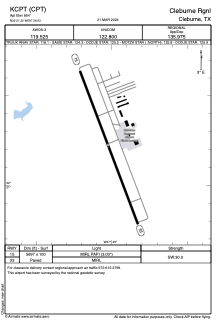


KCPT - Cleburne Rgnl
Located in Cleburne, United States
ICAO - CPT, IATA -
Data provided by AirmateGeneral information
Coordinates: N32°21'14" W97°26'2"
Elevation is 854 feet MSL.
Magnetic variation is 06° East View others Airports in Texas
Operational data
Special qualification required
Current time UTC:
Current local time:
Weather
METAR: KCPT 252015Z AUTO 14013G18KT 10SM BKN019 BKN025 BKN030 24/22 A2990 RMK A01
Communications frequencies: [VIEW]
Runways:
| RWY identifier | QFU | Length (ft) | Width (ft) | Surface | LDA (ft) |
| 15 | 159° | 5697 | 100 | ASPH | |
| 33 | 339° | 5697 | 100 | ASPH |
Airport contact information
Address: Cleburne United States