


KCOU - Columbia Rgnl
Located in Columbia, United States
ICAO - COU, IATA - COU
Data provided by AirmateGeneral information
Coordinates: N38°49'4" W92°13'4"
Elevation is 889 feet MSL.
Magnetic variation is 00° East View others Airports in Missouri
Operational data
Special qualification required
Current time UTC:
Current local time:
Weather
METAR: KCOU 250454Z AUTO 11009KT 10SM CLR 12/08 A3019 RMK AO2 SLP221 T01220078
TAF: KCOU 250520Z 2506/2606 11007KT P6SM SCT150 FM251700 13011G21KT P6SM BKN070 PROB30 2522/2602 4SM -SHRA BR OVC030 FM260200 13012G22KT P6SM OVC025
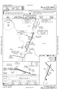
Communications frequencies: [VIEW]
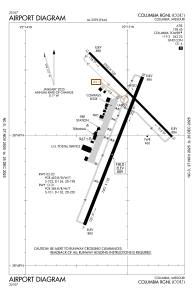
Runways:
| RWY identifier | QFU | Length (ft) | Width (ft) | Surface | LDA (ft) |
| 02 | 21° | 7401 | 150 | CONC | 6501 |
| 20 | 201° | 7401 | 150 | CONC | 6501 |
| 13 | 135° | 5500 | 100 | CONC | 5500 |
| 31 | 315° | 5500 | 100 | CONC | 5500 |
Airport contact information
Address: Columbia United States
