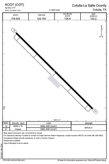


KCOT - Cotulla-La Salle County
Located in Cotulla, United States
ICAO - COT, IATA - COT
Data provided by AirmateGeneral information
Coordinates: N28°27'21" W99°13'2"
Elevation is 474 feet MSL.
Magnetic variation is 06° East View others Airports in Texas
Operational data
Special qualification required
Current time UTC:
Current local time:
Weather
METAR: KCOT 251753Z AUTO 18011G21KT 10SM FEW028 BKN039 OVC046 28/21 A2991 RMK AO2 SLP119 T02830206 10294 20239 58014
TAF: KCOT 251736Z 2518/2618 15015G25KT P6SM BKN035 FM260700 15012G20KT P6SM OVC025 TEMPO 2610/2613 14010KT FM261700 15013G21KT P6SM BKN050
Communications frequencies: [VIEW]
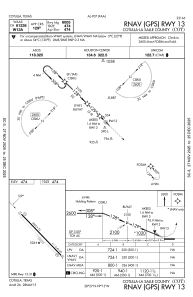
Runways:
| RWY identifier | QFU | Length (ft) | Width (ft) | Surface | LDA (ft) |
| 13 | 134° | 6005 | 75 | ASPH | |
| 31 | 314° | 6005 | 75 | ASPH |
Airport contact information
Address: Cotulla United States