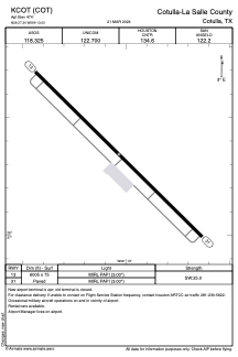


KCOT - Cotulla-La Salle County
Located in Cotulla, United States
ICAO - COT, IATA - COT
Data provided by AirmateGeneral information
Coordinates: N28°27'21" W99°13'2"
Elevation is 474 feet MSL.
Magnetic variation is 06° East View others Airports in Texas
Operational data
Special qualification required
Current time UTC:
Current local time:
Weather
METAR: KCOT 300853Z AUTO 13008KT 10SM OVC011 24/22 A2986 RMK AO2 SLP103 T02440217 58008 $
TAF: KCOT 300520Z 3006/0106 12015KT P6SM SCT015 SCT035 TEMPO 3006/3010 12008KT OVC015 FM301100 12006KT 5SM BR FEW010 BKN015 FM301600 14011KT P6SM SCT025 BKN045
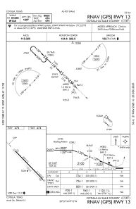
Communications frequencies: [VIEW]
Runways:
| RWY identifier | QFU | Length (ft) | Width (ft) | Surface | LDA (ft) |
| 13 | 134° | 6005 | 75 | ASPH | |
| 31 | 314° | 6005 | 75 | ASPH |
Airport contact information
Address: Cotulla United States