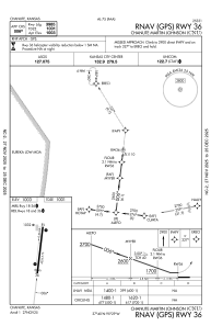
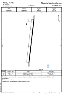


KCNU - Chanute Martin Johnson
Located in Chanute, United States
ICAO - CNU, IATA - CNU
Data provided by AirmateGeneral information
Coordinates: N37°40'4" W95°29'12"
Elevation is 1003 feet MSL.
Magnetic variation is 05° East View others Airports in Kansas
Operational data
Special qualification required
Current time UTC:
Current local time:
Weather
METAR: KCNU 282027Z AUTO 20015KT 10SM BKN015 BKN022 OVC050 21/17 A2982 RMK AO2 T02110167
TAF: KCNU 281740Z 2818/2918 20016G24KT P6SM SCT009 BKN015 FM282200 22012KT P6SM SCT015 BKN025 FM290000 24008KT P6SM FEW009 SCT015 FM290600 35007KT P6SM SKC
Communications frequencies: [VIEW]
Runways:
| RWY identifier | QFU | Length (ft) | Width (ft) | Surface | LDA (ft) |
| 18 | 187° | 4255 | 75 | ASPH | |
| 36 | 7° | 4255 | 75 | ASPH |
Airport contact information
Address: Chanute United States