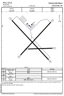


KCLI - Clintonville Muni
Located in Clintonville, United States
ICAO - CLI, IATA - CLI
Data provided by AirmateGeneral information
Coordinates: N44°36'47" W88°43'51"
Elevation is 825 feet MSL.
Magnetic variation is -02° East View others Airports in Wisconsin
Operational data
Special qualification required
Current time UTC:
Current local time:
Weather
METAR: KCLI 232355Z AUTO 35010KT 10SM SCT042 BKN060 OVC080 12/06 A2984 RMK AO2 T01170062 10202 20112 402040061
Communications frequencies: [VIEW]
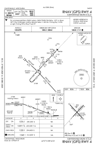
Runways:
| RWY identifier | QFU | Length (ft) | Width (ft) | Surface | LDA (ft) |
| 04 | 43° | 3812 | 75 | ASPH | |
| 22 | 223° | 3812 | 75 | ASPH | |
| 09 | 89° | 2002 | 170 | GRASS | |
| 27 | 268° | 2002 | 170 | GRASS | |
| 14 | 137° | 4599 | 75 | ASPH | |
| 32 | 317° | 4599 | 75 | ASPH |
Airport contact information
Address: Clintonville United States
