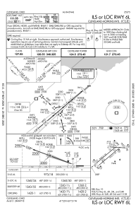
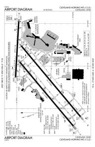


KCLE - Cleveland-Hopkins Intl
Located in Cleveland, United States
ICAO - CLE, IATA - CLE
Data provided by AirmateGeneral information
Coordinates: N41°24'34" W81°51'17"
Elevation is 799 feet MSL.
Magnetic variation is -08° East View others Airports in Ohio
Operational data
Special qualification required
Current time UTC:
Current local time:
Weather
METAR: KCLE 231851Z 22019G26KT 10SM OVC090 17/02 A2988 RMK AO2 PK WND 23032/1759 SLP132 T01670022
TAF: KCLE 231742Z 2318/2424 22018G30KT P6SM OVC070 FM232000 25014G22KT P6SM VCSH OVC060 FM232200 25008KT 5SM -SHRA OVC045 TEMPO 2400/2403 3SM -RA BKN025 FM240800 29008KT P6SM OVC015 FM241600 34012G20KT P6SM BKN020 FM242200 35008KT P6SM SCT025
Communications frequencies: [VIEW]
Runways:
| RWY identifier | QFU | Length (ft) | Width (ft) | Surface | LDA (ft) |
| 06R | 50° | 9953 | 150 | CONC | 8029 |
| 24L | 230° | 9953 | 150 | CONC | 9956 |
| 06L | 50° | 9000 | 150 | CONC | 9000 |
| 24R | 230° | 9000 | 150 | CONC | 9000 |
| 10 | 93° | 6018 | 150 | OTHER | 6018 |
| 28 | 273° | 6018 | 150 | OTHER | 6018 |
Airport contact information
Address: Cleveland United States