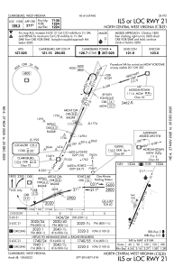


KCKB - North Central West Virginia
Located in Clarksburg, United States
ICAO - CKB, IATA - CKB
Data provided by AirmateGeneral information
Coordinates: N39°17'52" W80°13'39"
Elevation is 1223 feet MSL.
Magnetic variation is -08° East View others Airports in West Virginia
Operational data
Special qualification required
Current time UTC:
Current local time:
Weather
METAR: KCKB 182353Z 00000KT 10SM CLR 22/06 A3003 RMK AO2 SLP158 T02220061 10239 20194 56004
TAF: KCKB 182320Z 1900/1924 00000KT P6SM FEW250 FM191400 20006KT 5SM -SHRA BR OVC080 FM191600 21006KT 3SM -SHRA BR BKN045 FM192100 30009KT P6SM OVC012 FM192300 34005KT P6SM BKN070
Communications frequencies: [VIEW]
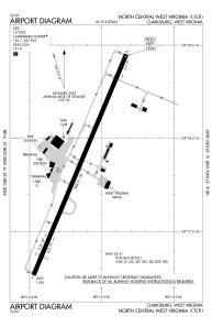
Runways:
| RWY identifier | QFU | Length (ft) | Width (ft) | Surface | LDA (ft) |
| 03 | 23° | 7800 | 150 | ASPH | 7130 |
| 21 | 203° | 7800 | 150 | ASPH | 7130 |
Airport contact information
Address: Clarksburg United States