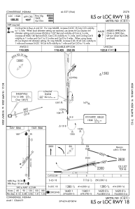
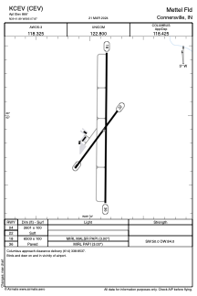


KCEV - Mettel Fld
Located in Connersville, United States
ICAO - CEV, IATA - CEV
Data provided by AirmateGeneral information
Coordinates: N39°41'53" W85°7'52"
Elevation is 866 feet MSL.
Magnetic variation is -04° East View others Airports in Indiana
Operational data
Special qualification required
Current time UTC:
Current local time:
Weather at : KRID - Richmond Muni ( 25 km )
METAR: KRID 230555Z AUTO 22007KT 10SM CLR 08/01 A3006 RMK AO2
Communications frequencies: [VIEW]
Runways:
| RWY identifier | QFU | Length (ft) | Width (ft) | Surface | LDA (ft) |
| 04 | 36° | 2601 | 100 | GRASS | |
| 22 | 216° | 2601 | 100 | GRASS | |
| 18 | 180° | 6503 | 100 | ASPH | |
| 36 | 360° | 6503 | 100 | ASPH |
Airport contact information
Address: Connersville United States