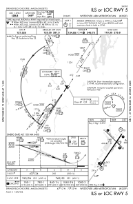
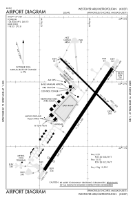


KCEF - Westover Arb/Metro
Located in Springfield/Chicopee, United States
ICAO - CEF, IATA - CEF
Data provided by AirmateGeneral information
Coordinates: N42°11'38" W72°32'5"
Elevation is 241 feet MSL.
Magnetic variation is -14° East View others Airports in Massachusetts
Operational data
Special qualification required
Current time UTC:
Current local time:
Weather
METAR: KCEF 291455Z 01006KT 10SM BKN024 OVC045 20/13 A2999 RMK AO2A SLP161 T01970127 52005
TAF: TAF KCEF 291201Z 2912/3018 VRB06KT 9999 BKN020 BKN090 QNH2997INS BECMG 2914/2915 01009KT 9999 SCT030 BKN090 BKN150 QNH2995INS WND VRB06KT AFT 2923 BECMG 3002/3003 VRB06KT 9999 BKN020 QNH3000INS BECMG 3005/3006 VRB06KT 6000 -DZ BR FEW008 OVC015 QNH3000INS BECMG 3010/3011 VRB06KT 3200 -RA BR OVC008 QNH2999INS BECMG 3015/3016 12009KT 9999 NSW BKN020 OVC080 QNH2997INS TX26/2920Z TN11/3010Z
Communications frequencies: [VIEW]
Runways:
| RWY identifier | QFU | Length (ft) | Width (ft) | Surface | LDA (ft) |
| 05 | 34° | 11597 | 300 | ASPH | |
| 23 | 214° | 11597 | 300 | ASPH | |
| 15 | 135° | 7085 | 150 | ASPH | |
| 33 | 315° | 7085 | 150 | ASPH |
Airport contact information
Address: Springfield/Chicopee United States