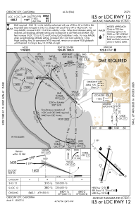
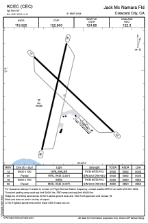


KCEC - Jack Mc Namara Fld
Located in Crescent City, United States
ICAO - CEC, IATA - CEC
Data provided by AirmateGeneral information
Coordinates: N41°46'49" W124°14'12"
Elevation is 60 feet MSL.
Magnetic variation is 14° East View others Airports in California
Operational data
Special qualification required
Current time UTC:
Current local time:
Weather
METAR: KCEC 251956Z AUTO 18015KT 9SM -RA BKN030 OVC035 11/11 A3010 RMK AO2 RAE19B50 SLP192 P0000 T01060106
TAF: KCEC 251952Z 2520/2618 17014KT 5SM -RA BR SCT005 BKN015 OVC025 TEMPO 2520/2521 3SM BR BKN005 FM252100 17010G21KT 3SM -RA BR SCT007 OVC015 TEMPO 2601/2604 BKN007 FM260400 19009KT 3SM -SHRA BR SCT003 OVC015 FM260900 20010G18KT 4SM -SHRA BR SCT015 OVC025 FM261300 22006KT P6SM VCSH SCT020 BKN035
Communications frequencies: [VIEW]
Runways:
| RWY identifier | QFU | Length (ft) | Width (ft) | Surface | LDA (ft) |
| 12 | 133° | 5002 | 150 | ASPH | 5002 |
| 18 | 193° | 5000 | 150 | ASPH | 4850 |
| 30 | 313° | 5002 | 150 | ASPH | 5002 |
| 36 | 13° | 5000 | 150 | ASPH | 4850 |
Airport contact information
Address: Crescent City United States