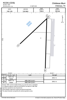


KCDS - Childress Muni
Located in Childress, United States
ICAO - CDS, IATA - CDS
Data provided by AirmateGeneral information
Coordinates: N34°26'2" W100°17'17"
Elevation is 1953 feet MSL.
Magnetic variation is 06° East View others Airports in Texas
Operational data
Special qualification required
Current time UTC:
Current local time:
Weather
METAR: KCDS 301853Z AUTO 22017G26KT 10SM CLR 33/16 A2979 RMK AO2 PK WND 20026/1850 SLP059 T03280156
TAF: KCDS 301720Z 3018/0118 21020G30KT P6SM SKC FM010000 17015KT P6SM SCT150 FM010600 18011KT P6SM FEW150 WS008/20040KT FM011300 19011KT P6SM SCT150
Communications frequencies: [VIEW]
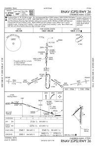
Runways:
| RWY identifier | QFU | Length (ft) | Width (ft) | Surface | LDA (ft) |
| 04 | 47° | 4425 | 60 | ASPH | |
| 22 | 227° | 4425 | 60 | ASPH | |
| 18 | 182° | 5949 | 75 | ASPH | |
| 36 | 2° | 5949 | 75 | ASPH |
Airport contact information
Address: Childress United States