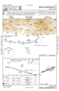
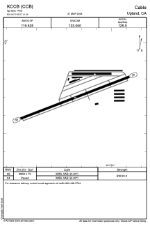


KCCB - Cable
Located in Upland, United States
ICAO - CCB, IATA - CCB
Data provided by AirmateGeneral information
Coordinates: N34°6'42" W117°41'15"
Elevation is 1443 feet MSL.
Magnetic variation is 14° East View others Airports in California
Operational data
Special qualification required
Current time UTC:
Current local time:
Communications frequencies: [VIEW]
Runways:
| RWY identifier | QFU | Length (ft) | Width (ft) | Surface | LDA (ft) |
| 06 | 69° | 3863 | 75 | ASPH | |
| 24 | 249° | 3863 | 75 | ASPH |
Airport contact information
Address: Upland United States
