


KBRL - Southeast Iowa Rgnl
Located in Burlington, United States
ICAO - BRL, IATA - BRL
Data provided by AirmateGeneral information
Coordinates: N40°46'59" W91°7'32"
Elevation is 698 feet MSL.
Magnetic variation is 01° East View others Airports in Iowa
Operational data
Special qualification required
Current time UTC:
Current local time:
Weather
METAR: KBRL 191953Z AUTO 00000KT 10SM CLR 30/16 A2994 RMK AO2 SLP133 T03000161
TAF: KBRL 191733Z 1918/2018 10006KT P6SM SCT200 FM192300 13005KT 6SM -SHRA SCT060 BKN100 FM200400 13009KT P6SM SCT030 OVC060 FM201300 18012KT 6SM -SHRA SCT050 BKN080
Communications frequencies: [VIEW]
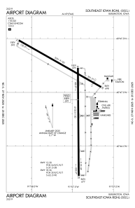
Runways:
| RWY identifier | QFU | Length (ft) | Width (ft) | Surface | LDA (ft) |
| 12 | 120° | 5351 | 100 | CONC | 5350 |
| 30 | 300° | 5351 | 100 | CONC | 4850 |
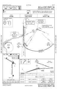
| 18 | 180° | 6102 | 100 | CONC | 6102 |
| 36 | 360° | 6102 | 100 | CONC | 6102 |
Airport contact information
Address: Burlington United States
