


KBRD - Brainerd Lakes Rgnl
Located in Brainerd, United States
ICAO - BRD, IATA - BRD
Data provided by AirmateGeneral information
Coordinates: N46°24'15" W94°8'2"
Elevation is 1232 feet MSL.
Magnetic variation is 03° East View others Airports in Minnesota
Operational data
Special qualification required
Current time UTC:
Current local time:
Weather
METAR: KBRD 191853Z AUTO 27017G25KT 10SM OVC031 00/M07 A3004 RMK AO2 UPB35E41 SLP188 P0000 T00001072
TAF: KBRD 191737Z 1918/2018 28016G25KT P6SM VCSH BKN040 TEMPO 1920/1924 3SM -SHSN BR OVC035 FM200300 27009G19KT P6SM OVC060 FM201000 30009G17KT P6SM BKN025 FM201300 30009G16KT P6SM BKN035
Communications frequencies: [VIEW]
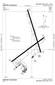
Runways:
| RWY identifier | QFU | Length (ft) | Width (ft) | Surface | LDA (ft) |
| 05 | 54° | 6512 | 150 | CONC | |
| 23 | 234° | 6512 | 150 | CONC | |
| 16 | 163° | 7100 | 150 | CONC | |
| 34 | 343° | 7100 | 150 | CONC |
Airport contact information
Address: Brainerd United States
