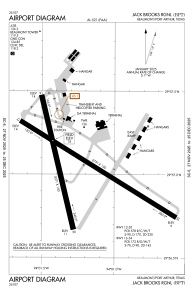


KBPT - Jack Brooks Rgnl
Located in Beaumont/Port Arthur, United States
ICAO - BPT, IATA - BPT
Data provided by AirmateGeneral information
Coordinates: N29°57'3" W94°1'15"
Elevation is 14 feet MSL.
Magnetic variation is 01° East View others Airports in Texas
Operational data
Special qualification required
Current time UTC:
Current local time:
Weather
METAR: KBPT 301153Z 09005KT 10SM CLR 18/18 A2994 RMK AO2 SLP139 70015 T01780178 10183 20167 53008 $
TAF: KBPT 301128Z 3012/0112 VRB04KT 3SM BR SCT005 FM301500 12006KT P6SM SCT100 FM302100 13009KT P6SM SCT100 FM010800 VRB04KT 5SM BR BKN020 FM011100 VRB05KT 3SM BR BKN020
Communications frequencies: [VIEW]
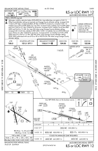
Runways:
| RWY identifier | QFU | Length (ft) | Width (ft) | Surface | LDA (ft) |
| 12 | 121° | 6751 | 150 | CONC | 6508 |
| 30 | 301° | 6751 | 150 | CONC | 6751 |
| 16 | 166° | 5071 | 150 | OTHER | 5070 |
| 34 | 346° | 5071 | 150 | OTHER | 5070 |
Airport contact information
Address: Beaumont/Port Arthur United States
