


KBNA - Nashville Intl
Located in Nashville, United States
ICAO - BNA, IATA - BNA
Data provided by AirmateGeneral information
Coordinates: N36°7'28" W86°40'41"
Elevation is 599 feet MSL.
Magnetic variation is -03° East View others Airports in Tennessee
Operational data
Special qualification required
Current time UTC:
Current local time:
Weather
METAR: KBNA 261453Z 12009KT 10SM FEW047 SCT055 SCT160 BKN250 18/13 A3011 RMK AO2 SLP193 T01780128 50008 $
TAF: KBNA 261123Z 2612/2712 07007KT 6SM -RA BR BKN045 OVC070 FM261400 14007KT P6SM BKN050 FM261700 16013G23KT P6SM SCT100
Communications frequencies: [VIEW]
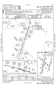
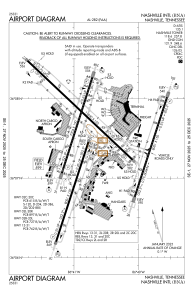
Runways:
| RWY identifier | QFU | Length (ft) | Width (ft) | Surface | LDA (ft) |
| 02C | 18° | 8001 | 150 | CONC | 7601 |
| 20C | 198° | 8001 | 150 | CONC | 8001 |
| 02R | 18° | 8001 | 150 | CONC | 8000 |
| 20L | 198° | 8001 | 150 | CONC | 8000 |
| 02L | 18° | 7704 | 150 | CONC | 7702 |
| 20R | 198° | 7704 | 150 | CONC | 7702 |
| 13 | 133° | 11030 | 150 | CONC | 9487 |
| 31 | 313° | 11030 | 150 | CONC | 9487 |
Airport contact information
Address: Nashville United States
