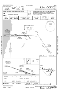
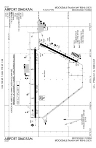


KBKV - Brooksville-Tampa Bay Rgnl
Located in Brooksville, United States
ICAO - BKV, IATA -
Data provided by AirmateGeneral information
Coordinates: N28°28'25" W82°27'20"
Elevation is 76 feet MSL.
Magnetic variation is -04° East View others Airports in Florida
Operational data
Special qualification required
Current time UTC:
Current local time:
Weather
METAR: KBKV 051853Z 00000KT 10SM FEW070 33/17 A3002 RMK AO2 SLP163 T03280167 $
Communications frequencies: [VIEW]
Runways:
| RWY identifier | QFU | Length (ft) | Width (ft) | Surface | LDA (ft) |
| 03 | 26° | 5014 | 150 | CONC | |
| 21 | 206° | 5014 | 150 | CONC | |
| 09 | 90° | 7001 | 150 | ASPH | |
| 27 | 270° | 7001 | 150 | ASPH |
Airport contact information
Address: Brooksville United States
