


KBKD - Stephens County
Located in Breckenridge, United States
ICAO - BKD, IATA - BKD
Data provided by AirmateGeneral information
Coordinates: N32°43'8" W98°53'30"
Elevation is 1284 feet MSL.
Magnetic variation is 07° East View others Airports in Texas
Operational data
Special qualification required
Current time UTC:
Current local time:
Weather
METAR: KBKD 162015Z AUTO 5SM HZ CLR 30/02 A2981 RMK AO2 T03020018
Communications frequencies: [VIEW]
Runways:
| RWY identifier | QFU | Length (ft) | Width (ft) | Surface | LDA (ft) |
| 04 | 45° | 2398 | 50 | ASPH | |
| 22 | 225° | 2398 | 50 | ASPH | |
| 13 | 135° | 2401 | 50 | ASPH | |
| 31 | 315° | 2401 | 50 | ASPH | |
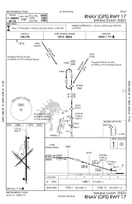
| 17 | 180° | 5002 | 100 | ASPH | |
| 35 | 360° | 5002 | 100 | ASPH |
Airport contact information
Address: Breckenridge United States