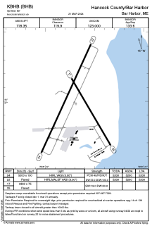


KBHB - Hancock County/Bar Harbor
Located in Bar Harbor, United States
ICAO - BHB, IATA - BHB
Data provided by AirmateGeneral information
Coordinates: N44°26'59" W68°21'41"
Elevation is 83 feet MSL.
Magnetic variation is -19° East View others Airports in Maine
Operational data
Special qualification required
Current time UTC:
Current local time:
Weather
METAR: KBHB 291856Z AUTO 36010G20KT 320V030 10SM CLR 17/04 A2997 RMK AO2 SLP151 T01720039
TAF: KBHB 291732Z 2918/3018 35012G20KT P6SM SKC FM300700 35007KT P6SM SKC FM301200 35009G17KT P6SM SKC
Communications frequencies: [VIEW]
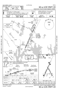
Runways:
| RWY identifier | QFU | Length (ft) | Width (ft) | Surface | LDA (ft) |
| 04 | 25° | 5200 | 100 | ASPH | 5200 |
| 22 | 205° | 5200 | 100 | ASPH | 5200 |
| 17 | 150° | 3363 | 75 | ASPH | |
| 35 | 330° | 3363 | 75 | ASPH |
Airport contact information
Address: Bar Harbor United States
