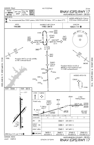
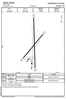


KBGD - Hutchinson County
Located in Borger, United States
ICAO - BGD, IATA - BGD
Data provided by AirmateGeneral information
Coordinates: N35°42'3" W101°23'37"
Elevation is 3055 feet MSL.
Magnetic variation is 07° East View others Airports in Texas
Operational data
Special qualification required
Current time UTC:
Current local time:
Weather
METAR: KBGD 192151Z AUTO 14008KT 10SM CLR 16/M01 A3013 RMK AO2 SLP190 T01611011
Communications frequencies: [VIEW]
Runways:
| RWY identifier | QFU | Length (ft) | Width (ft) | Surface | LDA (ft) |
| 03 | 40° | 3897 | 100 | ASPH | |
| 21 | 220° | 3897 | 100 | ASPH | |
| 17 | 178° | 6299 | 100 | ASPH | |
| 35 | 358° | 6299 | 100 | ASPH |
Airport contact information
Address: Borger United States