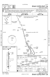
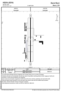


KBDN - Bend Muni
Located in Bend, United States
ICAO - BDN, IATA -
Data provided by AirmateGeneral information
Coordinates: N44°5'40" W121°12'1"
Elevation is 3459 feet MSL.
Magnetic variation is 19° East View others Airports in Oregon
Operational data
Special qualification required
Current time UTC:
Current local time:
Weather
METAR: KBDN 261315Z AUTO 22011KT 10SM 05/01 A2981 RMK AO2
TAF: KBDN 261120Z 2612/2712 22012KT P6SM BKN040 BKN070 FM262000 30007KT P6SM VCSH BKN050 FM270000 30008KT P6SM BKN070 FM270600 21005KT P6SM BKN050
Communications frequencies: [VIEW]
Runways:
| RWY identifier | QFU | Length (ft) | Width (ft) | Surface | LDA (ft) |
| 16 | 180° | 5201 | 75 | ASPH | |
| 34 | 360° | 5201 | 75 | ASPH |
Airport contact information
Address: Bend United States
