


KAZO - Kalamazoo/Battle Creek Intl
Located in Kalamazoo, United States
ICAO - AZO, IATA - AZO
Data provided by AirmateGeneral information
Coordinates: N42°14'4" W85°33'6"
Elevation is 873 feet MSL.
Magnetic variation is -03° East View others Airports in Michigan
Operational data
Special qualification required
Current time UTC:
Current local time:
Weather
METAR: KAZO 032153Z 35008KT 10SM CLR 22/15 A3002 RMK AO2 SLP163 T02170150
TAF: KAZO 031740Z 0318/0418 29007KT P6SM BKN022 FM032000 33007KT P6SM BKN035 BKN250 FM040000 36004KT P6SM BKN250 FM040900 06003KT 5SM BR OVC009 FM041300 10004KT 4SM BR BKN015 FM041400 12005KT P6SM BKN025 FM041600 16006KT P6SM OVC050
Communications frequencies: [VIEW]
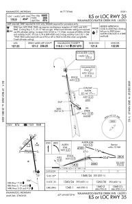
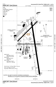
Runways:
| RWY identifier | QFU | Length (ft) | Width (ft) | Surface | LDA (ft) |
| 05 | 45° | 3438 | 100 | ASPH | 3439 |
| 23 | 225° | 3438 | 100 | ASPH | 3439 |
| 09 | 90° | 2800 | 60 | ASPH | 2800 |
| 27 | 270° | 2800 | 60 | ASPH | 2800 |
| 17 | 171° | 6502 | 150 | ASPH | 6502 |
| 35 | 351° | 6502 | 150 | ASPH | 6502 |
Airport contact information
Address: Kalamazoo United States
Other aviation service providers
Flight schools

Kal-Aero Flight Instruction
Kal-Aero Flight Instruction
kalaeroflightinstruction@gmail.com+1(269)459-8967