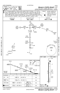


KAXS - Altus/Quartz Mountain Rgnl
Located in Altus, United States
ICAO - AXS, IATA - AXS
Data provided by AirmateGeneral information
Coordinates: N34°41'56" W99°20'18"
Elevation is 1433 feet MSL.
Magnetic variation is 05° East View others Airports in Oklahoma
Operational data
Special qualification required
Current time UTC:
Current local time:
Weather
METAR: KAXS 190135Z AUTO 04009KT 10SM CLR 14/08 A3008 RMK AO2
Communications frequencies: [VIEW]
Runways:
| RWY identifier | QFU | Length (ft) | Width (ft) | Surface | LDA (ft) |
| 17 | 180° | 5501 | 75 | CONC | |
| 35 | 360° | 5501 | 75 | CONC |
Airport contact information
Address: Altus United States
