


KATW - Appleton Intl
Located in Appleton, United States
ICAO - ATW, IATA - ATW
Data provided by AirmateGeneral information
Coordinates: N44°15'29" W88°31'9"
Elevation is 918 feet MSL.
Magnetic variation is -02° East View others Airports in Wisconsin
Operational data
Special qualification required
Current time UTC:
Current local time:
Weather
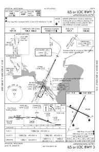
METAR: KATW 061945Z 12011G16KT 10SM CLR 21/08 A2997
TAF: KATW 061720Z 0618/0718 12009G15KT P6SM FEW060 FM070100 10007KT P6SM SCT250 FM070500 10006KT P6SM SCT250 WS014/15035KT FM070900 11009G17KT P6SM BKN150 WS014/15035KT FM071500 11013G24KT 4SM SHRA BKN028 WS014/15040KT
Communications frequencies: [VIEW]
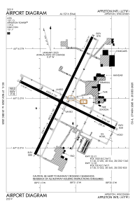
Runways:
| RWY identifier | QFU | Length (ft) | Width (ft) | Surface | LDA (ft) |
| 03 | 26° | 8003 | 150 | CONC | 8002 |
| 21 | 206° | 8003 | 150 | CONC | 8002 |
| 12 | 116° | 6502 | 150 | CONC | 6501 |
| 30 | 296° | 6502 | 150 | CONC | 6501 |
Airport contact information
Address: Appleton United States

