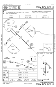


KANW - Ainsworth Rgnl
Located in Ainsworth, United States
ICAO - ANW, IATA - ANW
Data provided by AirmateGeneral information
Coordinates: N42°34'45" W99°59'35"
Elevation is 2588 feet MSL.
Magnetic variation is 06° East View others Airports in Nebraska
Operational data
Special qualification required
Current time UTC:
Current local time:
Weather
METAR: KANW 162235Z AUTO 32027G32KT 7SM -RA OVC009 08/07 A2949 RMK AO2 P0003 T00800071 TSNO
Communications frequencies: [VIEW]
Runways:
| RWY identifier | QFU | Length (ft) | Width (ft) | Surface | LDA (ft) |
| 17 | 179° | 6824 | 110 | ASPH | |
| 35 | 359° | 6824 | 110 | ASPH | |
| 13 | 134° | 5501 | 75 | ASPH | |
| 31 | 314° | 5501 | 75 | ASPH |
Airport contact information
Address: Ainsworth United States