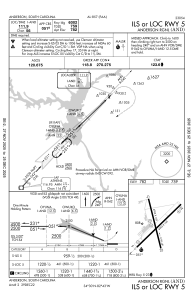
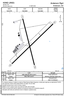


KAND - Anderson Rgnl
Located in Anderson, United States
ICAO - AND, IATA - AND
Data provided by AirmateGeneral information
Coordinates: N34°29'40" W82°42'34"
Elevation is 781 feet MSL.
Magnetic variation is -05° East View others Airports in South Carolina
Operational data
Special qualification required
Current time UTC:
Current local time:
Weather
METAR: KAND 040542Z AUTO 00000KT 10SM SCT035 SCT047 20/18 A3002 RMK AO2 LTG DSNT NE T02000183
Communications frequencies: [VIEW]
Runways:
| RWY identifier | QFU | Length (ft) | Width (ft) | Surface | LDA (ft) |
| 05 | 46° | 6002 | 149 | ASPH | |
| 23 | 226° | 6002 | 149 | ASPH | |
| 17 | 166° | 4996 | 149 | ASPH | |
| 35 | 346° | 4996 | 149 | ASPH |
Airport contact information
Address: Anderson United States