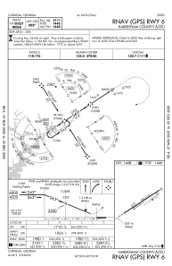
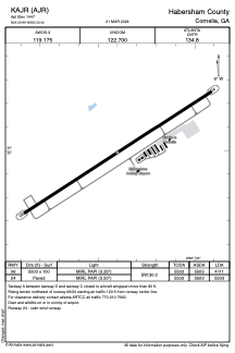


KAJR - Habersham County
Located in Cornelia, United States
ICAO - AJR, IATA -
Data provided by AirmateGeneral information
Coordinates: N34°29'59" W83°33'24"
Elevation is 1447 feet MSL.
Magnetic variation is -06° East View others Airports in Georgia
Operational data
Special qualification required
Current time UTC:
Current local time:
Weather
METAR: KAJR 250635Z AUTO 00000KT 7SM CLR 11/08 A3011 RMK AO2 T01050075
Communications frequencies: [VIEW]
Runways:
| RWY identifier | QFU | Length (ft) | Width (ft) | Surface | LDA (ft) |
| 06 | 57° | 5503 | 100 | ASPH | 4111 |
| 24 | 237° | 5503 | 100 | ASPH | 5503 |
Airport contact information
Address: Cornelia United States
