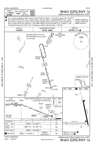
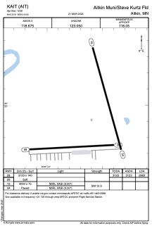


KAIT - Aitkin Muni/Steve Kurtz Fld
Located in Aitkin, United States
ICAO - AIT, IATA -
Data provided by AirmateGeneral information
Coordinates: N46°32'54" W93°40'36"
Elevation is 1206 feet MSL.
Magnetic variation is 00° East View others Airports in Minnesota
Operational data
Special qualification required
Current time UTC:
Current local time:
Weather
METAR: KAIT 252335Z AUTO 15014G18KT 10SM CLR 18/M01 A3001 RMK AO2
Communications frequencies: [VIEW]
Runways:
| RWY identifier | QFU | Length (ft) | Width (ft) | Surface | LDA (ft) |
| 08 | 87° | 3123 | 140 | GRASS | 2883 |
| 26 | 267° | 3123 | 140 | GRASS | |
| 16 | 164° | 4000 | 75 | ASPH | |
| 34 | 344° | 4000 | 75 | ASPH |
Airport contact information
Address: Aitkin United States
Other aviation service providers
Flight schools

Adventure North Flying Service, Llc
Adventure North Flying Service, Llc
adventurenorthllc@gmail.com2189274104