


KAFW - Perot Fld/Fort Worth Alliance
Located in Fort Worth, United States
ICAO - AFW, IATA - AFW
Data provided by AirmateGeneral information
Coordinates: N32°59'25" W97°19'10"
Elevation is 723 feet MSL.
Magnetic variation is 04° East View others Airports in Texas
Operational data
Special qualification required
Current time UTC:
Current local time:
Weather
METAR: KAFW 251153Z 18011KT 10SM FEW050 OVC060 22/18 A2997 RMK AO2 SLP139 T02170178 10233 20217 56004
TAF: KAFW 251120Z 2512/2612 18011KT P6SM FEW022 BKN070 FM251400 17008KT P6SM OVC025 FM251600 17015KT P6SM OVC015 FM252000 17019G29KT P6SM BKN021 FM260000 16017G27KT P6SM BKN035 FM260400 18020G30KT P6SM BKN019
Communications frequencies: [VIEW]
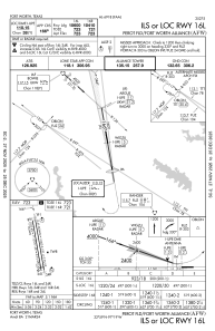
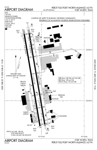
Runways:
| RWY identifier | QFU | Length (ft) | Width (ft) | Surface | LDA (ft) |
| 16R | 170° | 11010 | 150 | CONC | 10410 |
| 34L | 350° | 11010 | 150 | CONC | 10409 |
| 16L | 170° | 11000 | 150 | CONC | 10600 |
| 34R | 350° | 11000 | 150 | CONC | 11000 |
Airport contact information
Address: Fort Worth United States