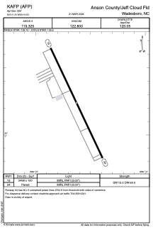


KAFP - Anson County/Jeff Cloud Fld
Located in Wadesboro, United States
ICAO - AFP, IATA -
Data provided by AirmateGeneral information
Coordinates: N35°1'14" W80°4'38"
Elevation is 299 feet MSL.
Magnetic variation is -07° East View others Airports in North Carolina
Operational data
Special qualification required
Current time UTC:
Current local time:
Weather
METAR: KAFP 241410Z AUTO 00000KT 10SM CLR 18/08 A3006 RMK AO2 T01800075
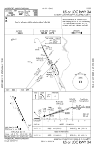
Communications frequencies: [VIEW]
Runways:
| RWY identifier | QFU | Length (ft) | Width (ft) | Surface | LDA (ft) |
| 16 | 155° | 5498 | 100 | ASPH | |
| 34 | 335° | 5498 | 100 | ASPH |
Airport contact information
Address: Wadesboro United States