


KADW - Joint Base Andrews
Located in Camp Springs, United States
ICAO - ADW, IATA - ADW
Data provided by AirmateGeneral information
Coordinates: N38°48'39" W76°52'1"
Elevation is 279 feet MSL.
Magnetic variation is -10° East View others Airports in Maryland
Operational data
Special qualification required
Current time UTC:
Current local time:
Weather
METAR: KADW 261155Z AUTO 06003KT 10SM CLR 09/04 A3040 RMK AO2 SLP302 T00850039 10085 20030 52018 $
TAF: TAF KADW 260900Z 2609/2715 07006KT 9999 FEW050 QNH3035INS BECMG 2613/2614 10012KT 9999 SCT060 QNH3042INS BECMG 2622/2623 12008KT 9999 SCT060 BKN200 QNH3044INS BECMG 2713/2714 14010G15KT 9999 BKN060 QNH3054INS TX17/2620Z TN05/2609Z
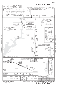
Communications frequencies: [VIEW]
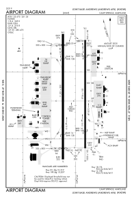
Runways:
| RWY identifier | QFU | Length (ft) | Width (ft) | Surface | LDA (ft) |
| 01R | 360° | 9756 | 150 | OTHER | |
| 19L | 180° | 9756 | 150 | OTHER | |
| 01L | 360° | 9318 | 200 | CONC | |
| 19R | 180° | 9318 | 200 | CONC |
Airport contact information
Address: Camp Springs United States