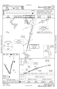
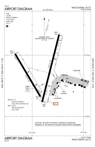


KACT - Waco Rgnl
Located in Waco, United States
ICAO - ACT, IATA - ACT
Data provided by AirmateGeneral information
Coordinates: N31°36'44" W97°13'49"
Elevation is 516 feet MSL.
Magnetic variation is 07° East View others Airports in Texas
Operational data
Special qualification required
Current time UTC:
Current local time:
Weather
METAR: KACT 300951Z AUTO 17010KT 7SM OVC012 21/20 A2990 RMK AO2 SLP117 T02110200
TAF: KACT 300858Z 3009/0106 16008KT P6SM BKN015 TEMPO 3010/3014 5SM BR FEW003 BKN007 FM301800 18012KT P6SM SCT025
Communications frequencies: [VIEW]
Runways:
| RWY identifier | QFU | Length (ft) | Width (ft) | Surface | LDA (ft) |
| 01 | 14° | 7107 | 150 | ASPH | 7005 |
| 19 | 194° | 7107 | 150 | ASPH | 6605 |
| 14 | 149° | 5103 | 150 | ASPH | 5103 |
| 32 | 329° | 5103 | 150 | ASPH | 5103 |
Airport contact information
Address: Waco United States
