


KABY - Southwest Georgia Rgnl
Located in Albany, United States
ICAO - ABY, IATA - ABY
Data provided by AirmateGeneral information
Coordinates: N31°32'8" W84°11'40"
Elevation is 196 feet MSL.
Magnetic variation is -05° East View others Airports in Georgia
Operational data
Special qualification required
Current time UTC:
Current local time:
Weather
METAR: KABY 252153Z 24003KT 10SM CLR 28/11 A3008 RMK AO2 SLP183 T02830106
TAF: KABY 251731Z 2518/2618 20005KT P6SM SCT060 FM261400 12004KT P6SM SKC
Communications frequencies: [VIEW]
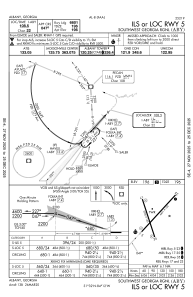
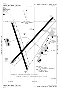
Runways:
| RWY identifier | QFU | Length (ft) | Width (ft) | Surface | LDA (ft) |
| 05 | 42° | 6601 | 148 | ASPH | 6601 |
| 23 | 222° | 6601 | 148 | ASPH | 6601 |
| 17 | 162° | 5219 | 148 | ASPH | |
| 35 | 342° | 5219 | 148 | ASPH |
Airport contact information
Address: Albany United States