


KABI - Abilene Rgnl
Located in Abilene, United States
ICAO - ABI, IATA - ABI
Data provided by AirmateGeneral information
Coordinates: N32°24'41" W99°40'55"
Elevation is 1790 feet MSL.
Magnetic variation is 05° East View others Airports in Texas
Operational data
Special qualification required
Current time UTC:
Current local time:
Weather
METAR: KABI 252152Z 16017G22KT 10SM FEW028 SCT045 OVC060 25/19 A2978 RMK AO2 PK WND 14026/2103 SLP062 T02500194
TAF: KABI 251742Z 2518/2618 17014G23KT P6SM BKN040 FM260000 17019G27KT P6SM OVC050 FM260700 18020G27KT P6SM VCTS OVC030CB PROB30 2609/2611 4SM TSRA BR BKN020CB FM261200 20014G21KT P6SM BKN150
Communications frequencies: [VIEW]
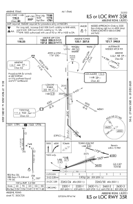
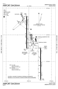
Runways:
| RWY identifier | QFU | Length (ft) | Width (ft) | Surface | LDA (ft) |
| 17R | 180° | 7208 | 150 | ASPH | 7202 |
| 35L | 360° | 7208 | 150 | ASPH | 7202 |
| 17L | 180° | 7198 | 150 | ASPH | 7198 |
| 35R | 360° | 7198 | 150 | ASPH | 7198 |
Airport contact information
Address: Abilene United States
