


K91 - Horton Muni
Located in Horton, United States
ICAO - K91, IATA -
Data provided by AirmateGeneral information
Coordinates: N39°40'44" W95°32'3"
Elevation is 1134 feet MSL.
Magnetic variation is 06° East View others Airports in Kansas
Operational data
Special qualification required
Current time UTC:
Current local time:
Weather at : KFNB - Brenner Fld ( 45 km )
METAR: KFNB 250253Z AUTO 12006KT 10SM SCT090 BKN110 18/03 A3011 RMK AO2 SLP192 T01830033 53005
Communications frequencies: [VIEW]
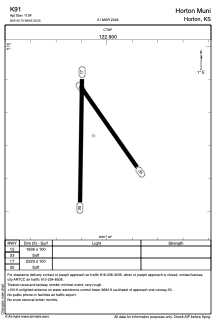
Runways:
| RWY identifier | QFU | Length (ft) | Width (ft) | Surface | LDA (ft) |
| 15 | 145° | 1636 | 100 | GRASS | |
| 33 | 325° | 1636 | 100 | GRASS | |
| 17 | 181° | 2223 | 100 | GRASS | |
| 35 | 1° | 2223 | 100 | GRASS |
Airport contact information
Address: Horton United States