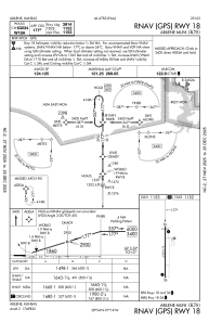
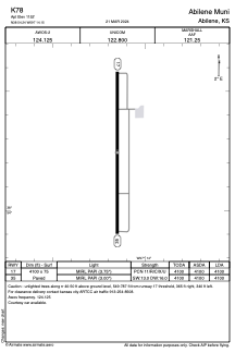


K78 - Abilene Muni
Located in Abilene, United States
ICAO - K78, IATA -
Data provided by AirmateGeneral information
Coordinates: N38°54'15" W97°14'9"
Elevation is 1152 feet MSL.
Magnetic variation is 07° East View others Airports in Kansas
Operational data
Special qualification required
Current time UTC:
Current local time:
Weather at : KSLN - Salina Rgnl ( 38 km )
METAR: KSLN 281953Z 29015G22KT 10SM BKN037 19/11 A2979 RMK AO2 SLP080 T01940106 $
TAF: KSLN 281740Z 2818/2918 29014G21KT P6SM SCT009 BKN015 FM282000 29015G23KT P6SM BKN035 FM290100 32011KT P6SM SCT060 FM291500 20009KT P6SM SKC
Communications frequencies: [VIEW]
Runways:
| RWY identifier | QFU | Length (ft) | Width (ft) | Surface | LDA (ft) |
| 17 | 180° | 4100 | 75 | CONC | 4100 |
| 35 | 0° | 4100 | 75 | CONC | 4100 |
Airport contact information
Address: Abilene United States
