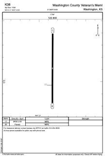


K38 - Washington County Veteran's Meml
Located in Washington, United States
ICAO - K38, IATA -
Data provided by AirmateGeneral information
Coordinates: N39°44'7" W97°2'51"
Elevation is 1436 feet MSL.
Magnetic variation is 06° East View others Airports in Kansas
Operational data
Special qualification required
Current time UTC:
Current local time:
Weather at : KMYZ - Marysville Muni ( 38 km )
METAR: KMYZ 260035Z AUTO 13014G25KT 10SM OVC015 14/12 A2977 RMK AO2 LTG DSNT S
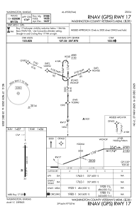
Communications frequencies: [VIEW]
Runways:
| RWY identifier | QFU | Length (ft) | Width (ft) | Surface | LDA (ft) |
| 17 | 180° | 3406 | 60 | CONC | |
| 35 | 0° | 3406 | 60 | CONC |
Airport contact information
Address: Washington United States