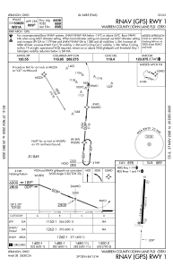
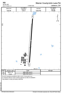


I68 - Warren County/John Lane Fld
Located in Lebanon, United States
ICAO - I68, IATA -
Data provided by AirmateGeneral information
Coordinates: N39°27'44" W84°15'7"
Elevation is 898 feet MSL.
Magnetic variation is -05° East View others Airports in Ohio
Operational data
Special qualification required
Current time UTC:
Current local time:
Communications frequencies: [VIEW]
Runways:
| RWY identifier | QFU | Length (ft) | Width (ft) | Surface | LDA (ft) |
| 01 | 4° | 4502 | 75 | ASPH | |
| 19 | 184° | 4502 | 75 | ASPH |
Airport contact information
Address: Lebanon United States
Other aviation service providers
Flight schools

Gentle Breeze Hot Air Balloon Company, Ltd
Gentle Breeze Hot Air Balloon Company, Ltd
Ballooning@HotAirBalloonRides.com+1(513)932-9007