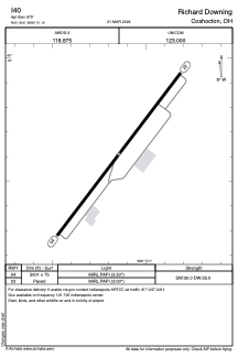


I40 - Richard Downing
Located in Coshocton, United States
ICAO - I40, IATA -
Data provided by AirmateGeneral information
Coordinates: N40°18'37" W81°51'9"
Elevation is 979 feet MSL.
Magnetic variation is -07° East View others Airports in Ohio
Operational data
Special qualification required
Current time UTC:
Current local time:
Weather at : KPHD - Harry Clever Fld ( 41 km )
METAR: KPHD 191911Z AUTO 31010KT 10SM OVC028 16/10 A2999 RMK AO2 T01560100
Communications frequencies: [VIEW]
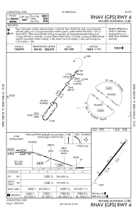
Runways:
| RWY identifier | QFU | Length (ft) | Width (ft) | Surface | LDA (ft) |
| 04 | 37° | 5001 | 75 | ASPH | |
| 22 | 217° | 5001 | 75 | ASPH |
Airport contact information
Address: Coshocton United States