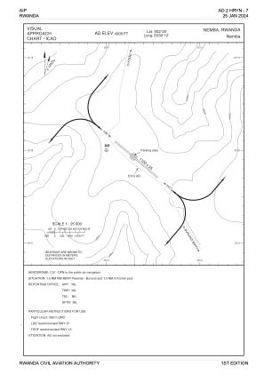


HRYN - Nemba
Located in Nyamata, Rwanda
ICAO - HRYN, IATA -
Data provided by AirmateGeneral information
Coordinates: S2°20'0" E30°12'0"
Elevation is 4905 feet MSL.
View others Airports in East
Operational data
Special qualification required
Current time UTC:
Current local time:
Weather at : HRYR - Kigali Intl ( 41 km )
METAR: HRYR 022300Z 04002KT 9999 BKN023 BKN100 19/19 Q1020 NOSIG
TAF: HRYR 022300Z 0300/0406 32004KT 9999 SCT023 BKN100 BECMG 0302/0305 00000KT 3000 BR SCT005 BKN018 FM 030800 27006KT 9999 BKN022 TEMPO 0310/0314 17015KT TSRA FEW020CB BKN022 BECMG 0318/0321 31008KT RA BKN020 BKN090 BECMG 0402/0405 00000KT 8000 SCT023 BKN100
Communications frequencies: [VIEW]
Runways:
| RWY identifier | QFU | Length (ft) | Width (ft) | Surface | LDA (ft) |
| 13 | 131° | 3609 | 82 | UNK | |
| 31 | 311° | 3609 | 82 | UNK |
Airport contact information
Address: Nyamata Rwanda