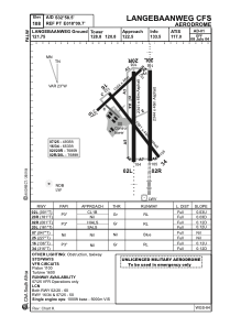


FALW - Langebaanweg (Mil - Unlicensed)
Located in Langebaanweg, South Africa
ICAO - FALW, IATA - SDB
Data provided by AirmateGeneral information
Coordinates: S32°58'8" E18°9'55"
Elevation is 108 feet MSL.
Magnetic variation is -25° East View others Airports in Western Cape
Operational data
Special qualification required
Current time UTC:
Current local time:
Communications frequencies: [VIEW]
Runways:
| RWY identifier | QFU | Length (ft) | Width (ft) | Surface | LDA (ft) |
| 02L | 1° | 7680 | 151 | ASPH | 7680 |
| 20R | 181° | 7680 | 151 | ASPH | 7680 |
| 02R | 1° | 7690 | 151 | ASPH | 7690 |
| 20L | 181° | 7690 | 151 | ASPH | 7690 |
| 16 | 136° | 5830 | 144 | ASPH | 5830 |
| 34 | 316° | 5830 | 144 | ASPH | 5830 |
| 07 | 47° | 4934 | 151 | ASPH | 4934 |
| 25 | 227° | 4934 | 151 | ASPH | 4934 |
Airport contact information
Address: Langebaanweg South Africa