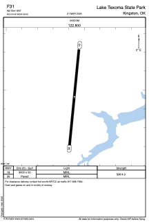


F31 - Lake Texoma State Park
Located in Kingston, United States
ICAO - F31, IATA -
Data provided by AirmateGeneral information
Coordinates: N33°59'28" W96°38'34"
Elevation is 693 feet MSL.
Magnetic variation is 06° East View others Airports in Oklahoma
Operational data
Special qualification required
Current time UTC:
Current local time:
Weather at : KDUA - Durant Rgnl/Eaker Fld ( 24 km )
METAR: KDUA 201415Z AUTO 06012KT 7SM -RA OVC011 12/11 A3019 RMK AO2
TAF: KDUA 201122Z 2012/2112 05008KT P6SM VCSH BKN015 OVC030 TEMPO 2012/2014 4SM -TSRA BR OVC010CB FM201400 07015KT P6SM -SHRA OVC015 TEMPO 2014/2018 4SM -TSRA OVC010CB FM202000 06012G18KT 6SM -SHRA OVC020 TEMPO 2020/2024 4SM -TSRA OVC015CB FM210100 04007KT P6SM OVC010 TEMPO 2101/2105 5SM -SHRA
Communications frequencies: [VIEW]
Runways:
| RWY identifier | QFU | Length (ft) | Width (ft) | Surface | LDA (ft) |
| 18 | 186° | 3000 | 50 | ASPH | |
| 36 | 6° | 3000 | 50 | ASPH |
Airport contact information
Address: Kingston United States