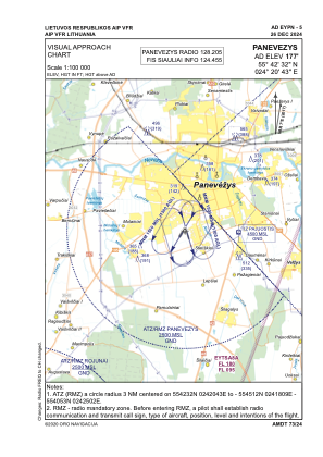


EYPN - Panevezys
Located in Panevezys, Lithuania
ICAO - EYPN, IATA - PNV
Data provided by AirmateGeneral information
Coordinates: N55°42'32" E24°20'43"
Elevation is 177 feet MSL.
Magnetic variation is 7° East View others Airports in Panevežys County
Operational data
Special qualification required
Current time UTC:
Current local time:
Weather at : EYSA - Siauliai/Military/International ( 63 km )
METAR: EYSA 270050Z AUTO 20004KT 9999NDV NSC 16/15 Q1015
TAF: TAF COR EYSA 262303Z 2700/2709 VRB05KT 5000 BR SCT045 TEMPO 2700/2705 SCT005 PROB40 TEMPO 2700/2705 1500 BKN005 BECMG 2705/2706 9000 NSW TEMPO 2706/2709 23010KT
Communications frequencies: [VIEW]
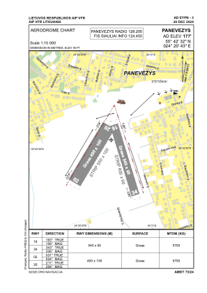
Runways:
| RWY identifier | QFU | Length (ft) | Width (ft) | Surface | LDA (ft) |
| 02 | 31° | 1608 | 328 | GRASS | |
| 20 | 211° | 1608 | 328 | GRASS | |
| 16 | 163° | 1772 | 197 | GRASS | |
| 34 | 343° | 1772 | 197 | GRASS |
Airport contact information
Address: Panevezys Lithuania
