


EYMA - Mazeikiai/J.Kumpikeviciaus
Located in Mazeikiai, Lithuania
ICAO - EYMA, IATA -
Data provided by AirmateGeneral information
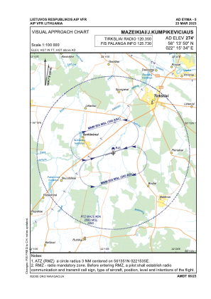
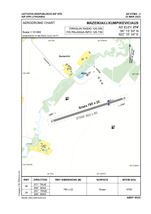
Coordinates: N56°13'50" E22°15'34"
Elevation is 274 feet MSL.
Magnetic variation is 7° East View others Airports in Telšiai County
Operational data
Special qualification required
Current time UTC:
Current local time:
Weather at : EYPA - Palanga/International ( 78 km )
METAR: EYPA 270450Z 13005KT CAVOK 16/13 Q1014
TAF: TAF EYPA 270502Z 2706/2806 VRB05KT 9000 NSC TEMPO 2706/2709 SCT040CB TEMPO 2712/2721 SHRA SCT010 BKN020CB BECMG 2723/2724 BKN010 OVC020 TEMPO 2802/2806 3000 SHRA BKN005 BKN015CB
Communications frequencies: [VIEW]
Runways:
| RWY identifier | QFU | Length (ft) | Width (ft) | Surface | LDA (ft) |
| 06 | 71° | 2592 | 72 | GRASS | |
| 24 | 251° | 2592 | 72 | GRASS |
Airport contact information
Address: Mazeikiai Lithuania