

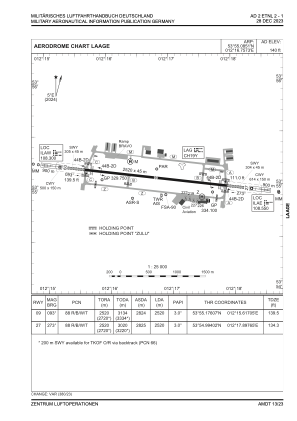


ETNL - Laage
Located in Laage, Germany
ICAO - ETNL, IATA - RLG
Data provided by AirmateGeneral information
Coordinates: N53°55'5" E12°16'45"
Elevation is 140 feet MSL.
Magnetic variation is 4.53° East View others Airports in Mecklenburg-Vorpommern
Operational data
Special qualification required
Current time UTC:
Current local time:
Weather
METAR: ETNL 261120Z 18010KT 9999 BKN045 11/02 Q1004 BLU
TAF: TAF ETNL 261022Z 2611/2623 19005KT 9999 NSW FEW020 BKN035 TEMPO 2613/2618 21010KT 7000 -RA FEW012 BKN020
Communications frequencies: [VIEW]
Runways:
| RWY identifier | QFU | Length (ft) | Width (ft) | Surface | LDA (ft) |
| 09 | 98° | 8268 | 148 | CONC+ASPH | 8268 |
| 27 | 278° | 8268 | 148 | CONC+ASPH | 8268 |
Airport contact information
Address: Laage Germany