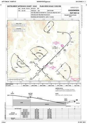


ENEG - Eggemoen
Located in Honefoss, Norway
ICAO - ENEG, IATA -
Data provided by AirmateGeneral information
Coordinates: N60°12'50" E10°19'2"
Elevation is 653 feet MSL.
Magnetic variation is 3.6° East View others Airports in Buskerud
Operational data
Special qualification required
Current time UTC:
Current local time:
Weather at : ENGM - Gardermoen ( 42 km )
METAR: ENGM 291750Z 21013KT CAVOK 10/03 Q1019 NOSIG
TAF: TAF ENGM 291700Z 2918/3018 22008KT 9999 FEW035 BECMG 2922/2924 OVC003 PROB40 2924/3008 0500 FG VV001 BECMG 3008/3010 SCT010 TEMPO 3011/3018 FEW030CB SCT060
Communications frequencies: [VIEW]
Runways:
| RWY identifier | QFU | Length (ft) | Width (ft) | Surface | LDA (ft) |
| 04 | 0° | 5791 | 148 | Asphalt | |
| 22 | 0° | 5791 | 148 | Asphalt |
Airport contact information
Address: Honefoss Norway
