


EHLW - Leeuwarden/Leeuwarden
Located in Leeuwarden, Netherlands
ICAO - EHLW, IATA - LWR
Data provided by AirmateGeneral information
Coordinates: N53°13'31" E5°45'9"
Elevation is 3 feet MSL.
Magnetic variation is +2.000° East View others Airports in Friesland
Operational data
Special qualification required
Current time UTC:
Current local time:
Weather
METAR: EHLW 281029Z AUTO 20015KT 170V230 9999 RA SCT036 BKN040 BKN047 15/09 Q1005 BLU
TAF: TAF EHLW 280848Z 2809/2821 18012G22KT 9999 BKN048 BECMG 2810/2812 20018G34KT PROB40 TEMPO 2810/2817 21020G38KT FEW015 SCT020CB BKN025
Communications frequencies: [VIEW]
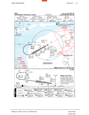
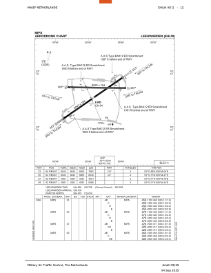
Runways:
| RWY identifier | QFU | Length (ft) | Width (ft) | Surface | LDA (ft) |
| 27 | 270° | 6561 | 164 | CONC+ASPH | 6561 |
| 09 | 90° | 6561 | 164 | CONC+ASPH | 6368 |
| 23 | 236° | 8045 | 164 | CONC+ASPH | 7863 |
| 05 | 56° | 8045 | 164 | CONC+ASPH | 8036 |
Airport contact information
Address: Leeuwarden Netherlands