


EHHO - Hoogeveen/Hoogeveen
Located in Hoogeveen, Netherlands
ICAO - EHHO, IATA -
Data provided by AirmateGeneral information
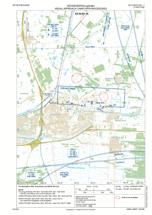
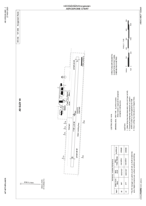
Coordinates: N52°43'51" E6°30'58"
Elevation is 40 feet MSL.
Magnetic variation is 2.0641° East View others Airports in Drente
Operational data
Special qualification required
Current time UTC:
Current local time:
Weather at : EHGG - Groningen/Eelde ( 44 km )
METAR: EHGG 070825Z AUTO 02004KT 340V080 9999 BKN014 BKN016 14/10 Q1018 BECMG SCT015
TAF: TAF EHGG 070453Z 0706/0812 02004KT CAVOK BECMG 0718/0721 BKN012 PROB40 0720/0807 7000 BKN008 BECMG 0807/0810 SCT015
Communications frequencies: [VIEW]
Runways:
| RWY identifier | QFU | Length (ft) | Width (ft) | Surface | LDA (ft) |
| 09 | 94° | 3904 | 79 | GRASS | |
| 27 | 274° | 3904 | 79 | GRASS |
Airport contact information
Address: Hoogeveen Netherlands
Other aviation service providers
Flight schools

Avia Noord Flight Training Center
Avia Noord Flight Training Center
rsloots@home.nl+31625022685
+31625022685
+31625022685
