


EGLJ - Chalgrove
Located in Oxford, United Kingdom
ICAO - EGLJ, IATA -
Data provided by AirmateGeneral information
Coordinates: N51°40'28" W1°5'7"
Elevation is 240 feet MSL.
View others Airports in England
Operational data
Special qualification required
Current time UTC:
Current local time:
Weather at : EGUB - Benson ( 7 km )
METAR: EGUB 190850Z 29012KT 9999 FEW024 BKN035 12/07 Q1016 TEMPO SCT024 RMK BLU TEMPO WHT
TAF: TAF EGUB 190717Z 1909/1918 31012KT 9999 FEW020 PROB30 TEMPO 1909/1912 SCT016 PROB30 TEMPO 1911/1916 34015G25KT
Communications frequencies: [VIEW]
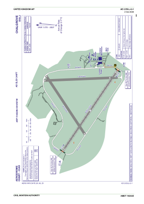
Runways:
| RWY identifier | QFU | Length (ft) | Width (ft) | Surface | LDA (ft) |
| 12 | 124° | 6004 | 151 | UNK | |
| 30 | 304° | 6004 | 151 | UNK | |
| 06 | 59° | 4347 | 151 | ASP | |
| 18 | 178° | 4186 | 151 | ASP | |
| 24 | 239° | 4347 | 151 | ASP | |
| 36 | 358° | 4186 | 151 | ASP |
Airport contact information
Address: Oxford United Kingdom